Recommendable!
Showing posts with label seismology. Show all posts
Showing posts with label seismology. Show all posts
Saturday, October 18, 2025
Sunday, July 20, 2025
Japan completes a new sprawling undersea earthquake-detection system this summer
Good news!
"To help mitigate future seismic disasters, Japan has built a sprawling undersea earthquake-detection system capable of providing up to 20 additional minutes of warning time before tsunamis hit coastal areas. During Fukushima, residents had just 10 minutes of warning."
"... With the final N-net link set up this June, the complete system increases warning times by 20 seconds for earthquakes and a full 20 minutes for tsunamis—enough time to divert incoming flights and close sea gates in busy ports.” ..."
"... Within months of the 2011 [Fukushima] earthquake, the Japanese government began to build S-net (Seafloor Observation Network for Earthquakes and Tsunamis). S-net wired the nation’s earthquake-detection network to the Japan Trench, the seismologically active offshore region where the 2011 earthquake began. Roughly 3,540 miles of cable now zigzag across 116,000 square miles of ocean to connect 150 observatories on the ocean floor. Each contains 14 distinct sensing channels, including seismometers and accelerometers, as well as pressure gauges to measure waves passing overhead.
This network—the first part of the larger network that was completed in June 2025—was finished in 2017. When a magnitude 6.0 quake struck the following year, alerts reached the cities before the first jolt hit—a full 20 seconds before the nearest land seismometer rang its alarm—allowing precious time to slow bullet trains and broadcast warnings. ..."
Japan Wires the Ocean with an Earthquake-Sensing ‘Nervous System’ (original news) "Japan’s new earthquake-detection network lengthens warning times, and researchers in Wales have harnessed nuclear blast detectors to gauge tsunami risks. But the U.S. lags in monitoring the massive Cascadia megathrust fault"

Monday, January 27, 2025
Starting to understand two strange hot islands of the size of continents deep in the Earth’s lower mantle
Amazing stuff! Plate tectonics and a well flowing mantle are apparently not the whole story!
"Deep inside Earth there are mysterious and fascinating regions the size of continents at the boundary between the core and mantle, and earth scientists have just cracked the mystery of what they’re made of.
Known as “Large Low Seismic Velocity Provinces”, or LLSVPs, the regions cause seismic waves to slow down. ...
One is found under Africa, the other under the Pacific Ocean.
“These 2 large islands are surrounded by a graveyard of tectonic plates which have been transported there by a process called ‘subduction’, where one tectonic plate dives below another plate ...
study looked at whole-Earth oscillations – seismic waves caused by very large earthquakes, which make the planet ring like a bell for weeks or even months – to learn more about LLSVPs. ..."
"... In this type of research, seismologists make good use of oscillations caused by really large earthquakes, preferably quakes that take place at great depths, such as the great Bolivia earthquake of 1994. “It never made it into the newspapers, because it took place at a large depth of 650 km and luckily did not result in any damage or casualties at the Earth’s surface,” ... The whole Earth oscillations, or tones, are mathematically described in such a way that we can easily ‘read’ the damping (i.e. how loud the oscillation is) due to a specific structure and separate it from the wave speed (i.e. how much out of tune it is). “Which is impressive, because the damping of the signal is only one-tenth of the total amount of information that we can unravel from these oscillations.” For this type of research, it is not necessary to wait until another earthquake occurs. The data from previous earthquakes is just as useful. “We can go back to 1975, because from that year onwards, seismometers became good enough to give us data of such high quality that they are useful for our research.” ..."
From the abstract:
"Seismic tomographic models based only on wave velocities have limited ability to distinguish between a thermal or compositional origin for Earth’s 3D structure. Complementing wave velocities with attenuation observations can make that distinction, which is fundamental for understanding mantle convection evolution. However, global 3D attenuation models are only available for the upper mantle at present.
Here we present a 3D global model of attenuation for the whole mantle made using whole-Earth oscillations, constraining even spherical harmonics up to degree four. In the upper mantle, we find that high attenuation correlates with low velocity, indicating a thermal origin, in agreement with previous studies.
In the lower mantle, we find the opposite and observe the highest attenuation in the ‘ring around the Pacific’, which is seismically fast, and the lowest attenuation in the large low-seismic-velocity provinces (LLSVPs). Comparing our model with wave speeds and attenuation predicted by a laboratory-based viscoelastic model suggests that the circum-Pacific is a colder and small-grain-size region, surrounding the warmer and large-grain-size LLSVPs. Viscosities calculated for the inferred variations in grain size and temperature confirm LLSVPs as long-lived, stable features."
Subterranean ‘islands’: strongholds in a potentially less turbulent world (original news release) "Deeply hidden in Earth’s mantle there are two huge ‘islands’ with the size of a continent. New research from Utrecht University, published in Nature, shows that these regions are not only hotter than the surrounding graveyard of cold sunken tectonic plates, but also that they must be ancient: at least half a billion years old, perhaps even older. These observations contradict the idea of a well-mixed and fast flowing Earth’s mantle, a theory that is becoming more and more questioned. “There is less flow in Earth’s mantle than is commonly thought.”"
Global 3D model of mantle attenuation using seismic normal modes (no public access)
Location of the LLSVPs and a schematic representation of the Earth's cross-section for speed and damping of the seismic waves.

Schematic representation of the process of subduction of tectonic plates and of a mantle plume rising from an LLSVP. In the latter, the mineral grains are larger than those in the subducted plates.

Saturday, August 10, 2024
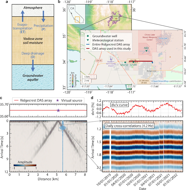
Seismic Detectors Measure Soil Moisture Using Traffic Noise
Amazing stuff!
"The new method relies upon seismic technology that normally measures how the ground shakes during earthquakes. However, it can also detect the vibrations of human activity, like traffic. As these vibrations pass through the ground, they are slowed down by the presence of water—the more moisture, the slower the vibration moves. The new study measures the water content in the vadose zone through seismic rumblings from everyday traffic. ...
The new method is based on a technique ... called distributed acoustic sensing (DAS). With this technique, lasers are pointed into unused underground fiber-optic cables (like the kind that provides internet). As a seismic wave, or any kind of vibration, passes through the cable, the laser light bends and refracts. Measuring the wiggles in this laser light gives researchers information about the passing wave, making the 10-kilometer cable equivalent to a line of thousands of conventional seismic sensors. ..."
From the abstract:
"Vadose zone soil moisture is often considered a pivotal intermediary water reservoir between surface and groundwater in semi-arid regions. Understanding its dynamics in response to changes in meteorologic forcing patterns is essential to enhance the climate resiliency of our ecological and agricultural system. However, the inability to observe high-resolution vadose zone soil moisture dynamics over large spatiotemporal scales hinders quantitative characterization. Here, utilizing pre-existing fiber-optic cables as seismic sensors, we demonstrate a fiber-optic seismic sensing principle to robustly capture vadose zone soil moisture dynamics. Our observations in Ridgecrest, California reveal sub-seasonal precipitation replenishments and a prolonged drought in the vadose zone, consistent with a zero-dimensional hydrological model. Our results suggest a significant water loss of 0.25 m/year through evapotranspiration at our field side, validated by nearby eddy-covariance based measurements. Yet, detailed discrepancies between our observations and modeling highlight the necessity for complementary in-situ validations. Given the escalated regional drought risk under climate change, our findings underscore the promise of fiber-optic seismic sensing to facilitate water resource management in semi-arid regions."
Fig. 1: Conceptual model for the vadose zone water dynamics and time-lapse seismology example on Ridgecrest DAS array.
Monday, June 17, 2024
Study confirms the rotation of Earth's solid inner core within the outer liquid core has slowed since 2010
Amazing stuff! Or how little we still know about our planet and its climate!
More surprising why is this not linked to Climate Change? There is no CO2 or other so called green house gases involved? Caution: satire
"USC scientists have proven that the Earth’s inner core is backtracking — slowing down — in relation to the planet’s surface, as shown in new research published Wednesday in Nature.
Movement of the inner core has been debated by the scientific community for two decades, with some research indicating that the inner core rotates faster than the planet’s surface. The new USC study provides unambiguous evidence that the inner core began to decrease its speed around 2010, moving slower than the Earth’s surface. ..."
Movement of the inner core has been debated by the scientific community for two decades, with some research indicating that the inner core rotates faster than the planet’s surface. The new USC study provides unambiguous evidence that the inner core began to decrease its speed around 2010, moving slower than the Earth’s surface. ..."
From the abstract:
"The solid inner core, suspended within the liquid outer core and anchored by gravity, has been inferred to rotate relative to the surface of Earth or change over years to decades based on changes in seismograms from repeating earthquakes and explosions. It has a rich inner structure and influences the pattern of outer core convection and therefore Earth’s magnetic field. Here we compile 143 distinct pairs of repeating earthquakes, many within 16 multiplets, built from 121 earthquakes between 1991 and 2023 in the South Sandwich Islands. We analyse their inner-core-penetrating PKIKP waves recorded on the medium-aperture arrays in northern North America. We document that many multiplets exhibit waveforms that change and then revert at later times to match earlier events. The matching waveforms reveal times at which the inner core re-occupies the same position, relative to the mantle, as it did at some time in the past. The pattern of matches, together with previous studies, demonstrates that the inner core gradually super-rotated from 2003 to 2008, and then from 2008 to 2023 sub-rotated two to three times more slowly back through the same path. These matches enable precise and unambiguous tracking of inner core progression and regression. The resolved different rates of forward and backward motion suggest that new models will be necessary for the dynamics between the inner core, outer core and mantle."
USC study confirms the rotation of Earth’s inner core has slowed (original news release) A new study provides clear evidence that the inner core began to decrease its speed around 2010.
The inner core began to decrease its speed around 2010, moving slower than the Earth’s surface.

Satellite data reveal anomalies up to 19 days before 2023 Turkey earthquake
Good news! Hopefully, we will find more confirmation and make earthquake prediction a routine.
Let's add an earthquake forecast to the daily news of earthquake prone regions! (just kidding)
"Earthquakes may betray their impending presence much earlier than previously thought through a variety of anomalies present in the ground, atmosphere and ionosphere that can be detected using satellites, a recent study in the Journal of Applied Geodesy suggests. ...
Such anomalies are known as earthquake precursors, and although researchers are aware of them, it has been difficult to definitively identify a pattern of so-called red flags that could indicate an impending earthquake. This is because of the complexity of precursor interactions and their variability in different earthquakes and geographical regions. However, with every earthquake that researchers analyze using increasingly sophisticated satellite technology, these patterns are slowly emerging. ...
Professor Mehdi Akhoondzadeh of the University of Tehran assessed a variety of satellite data from the run up to and aftermath of two earthquakes that occurred on 6 February 2023 near the border between Turkey and Syria. This included data from the Chinese seismo-electromagnetic satellite, CSES-01, and the Swarm satellite mission which consists of three satellites from the European Space Agency. ..."
From the abstract:
"On 6 February 2023, at 01:17:35 and 10:24:49 UTC (LT = UTC + 03:00) two earthquakes with magnitude 7.8 (37.166° N, 37.042° E, depth ∼ 17.9 km) and 7.5 (38.024° N, 37.203° E, depth ∼ 10 km), respectively, heavily struck southern and central Turkey and northern and western Syria. The purpose of this study is to investigate the relation between pre-earthquake anomalies observed in different layers of the earth system and explore the earthquake mechanism of LAIC (Lithospheric Atmospheric Ionospheric Coupling) associated with earthquake precursors. To achieve this goal, electron density and temperature variations obtained from CSES-01 data in the Dobrovolsky’s area the Turkey earthquakes are analyzed in the period from November 1, 2022 to February 10, 2023. Since investigating the LAIC mechanism requires multi-precursor analysis, anomalies obtained from CSES-01 data were compared with the behavior of anomalies obtained from other lithospheric, atmospheric and ionospheric precursors in the same location and time of the study area.
These anomalies that were analyzed in the previous study are:
(1) TEC data obtained from GPS-GIM maps,
(2) electron density and temperature variations obtained from Swarm satellites (Alpha, Bravo and Charlie) measurements,
(3) Atmospheric data including water vapour, methane, ozone, CO and AOD obtained from the measurements of OMI and AIRS satellites, and
(4) Lithospheric data including number of earthquakes obtained from USGS and also surface temperature obtained from the measurements of AIRS satellite. It should be noted that clear anomalies are observed between 1 and 5 days before the earthquake in electron density and temperature variations measured by CSES-01 during the day and night and they are in good agreement with the variations in the Swarm satellites data and GPS-TEC.
The interesting and significant finding is that lithospheric anomalies are detected in the land surface temperature data in the time interval of 19–12 days before the earthquake, and then most of the atmospheric anomalies are observed in the time period of 10–5 days prior to the earthquake and at the end striking ionospheric anomalies are revealed during 5–1 days preceding the earthquake. Therefore, the results of this study confirm the sequence of appearing of earthquake precursors from the lower layers of the lithosphere to the upper layers of the ionosphere during 1–15 days before the earthquake, and finally proving the LAIC mechanism can significantly contribute to the efficiency and lower uncertainty of earthquake early warning systems in the future."
Fig. 1 The intensity map and geographic location of the 2023 Turkey earthquake. A black star indicates the earthquake epicenter

Fig 2 Variations of solar-geomagnetic indices of (a) a p, (b) Dst and (c) F10.7, in the time period of 1 November, 2022 to 10 February 2023. The abscissa represents the days relative to the Turkey (06 February 2023) earthquake day. A black asterisk “*” indicates the earthquake origin time. The values of geomagnetic indices (a and b) are displayed in quiet conditions with green color and in non-quiet geomagnetic conditions with red color.

Sunday, April 21, 2024
Thousands of Deaths Averted in Taiwan Earthquake
Recommendable! A short backgrounder! Human ingenuity! How miracles happen!
"Summary: Amidst the recent devastation caused by a significant earthquake in Taiwan on April 3, the nation’s response showcased its progress in earthquake readiness, often overlooked in the headlines. Since the 1999 Jiji earthquake, Taiwan has made substantial strides in fortifying its infrastructure, improving construction standards, and advancing early-warning systems. This can serve as a model for global disaster preparedness."
Thursday, July 21, 2022
The earthquake that changed history: 1755 in Lisbon
Update of 11/7/2022: Apparently, Lisbon is prone to heavy earthquakes. "Chronologically, it was the third known large scale earthquake to hit the city (following those of 1321 and 1531)". Every about two hundred years? The next one is overdue?
The earthquake of 1755 shaked Christianity! All churches were destroyed on a major holy day of worshiping. Only the brothel survived so they say.
Recommendable! The day the modern age was born!
Why the heck were the Portuguese language speakers not translated by voice???? In this day and age with AI this is as easy as pie!
Friday, May 24, 2019
More Underwater Seismometers Are Finally Coming
Posted: 5/24/2019
Much to my surprise, I learnt today that, after decades of trying, finally submarine seismometers are going to be deployed in larger numbers.
Here is the article: Deploying seismometers where they’re needed most: Underwater Geophysicists hope to use some combination of three approaches to remedy the dearth of seismic data from the oceans.
Quotes from the above article (emphasis added):
- “Whereas about 1900 seismometers have collected data in the ocean over the past 20 years, the nongovernmental International Seismological Centre lists about 11 500 active sensors on land globally” [Shocking!]
- “The engineering of a modern-day ocean-bottom seismometer (OBS) ... “They’re basically like robots that don’t talk to home for a year, ...” [What? For a year?]
- “... high-quality OBS costs about $100 000 to build, whereas a land-based seismometer is about one-fifth of that price”
- “Over the past several years, …. scientists have shown that it’s feasible to attach seismic sensors to fiber-optic cable with a negligible effect on the cable’s reliability. Seismometers known as SMART sensors would collect seismic data using a small fraction of the cable’s power and bandwidth”
- “ It’s a floating network of seismometers known as MERMAID, or Mobile Earthquake Recording in Marine Areas by Independent Divers. The instruments are mobile, are about a third as expensive as OBSs, and can be deployed in remote locations without the need for a return trip to collect data. They drift and float in the water column listening for earthquakes. Each time they sense one, they record the data, move to the surface, and transmit the information to a satellite. ... This map shows the location in the Pacific of the 25 currently deployed MERMAIDs.” [Only 25 deployed?]
Perhaps, these seismometers will shed more light on e.g. sea level rise in some coastal areas of our globe!
This tidbit confirms once more that Global Warming (a.k.a. Climate Change) is the greatest hoax perpetrated on humanity in generations! We still know so little about the sun and the oceans that this constant indoctrination with the climate religion is unbearable!
Subscribe to:
Posts (Atom)